
Coastal Wind Resource Assessment
An NLR assessment provides an update on wind energy potential and spatial characteristics along the coastlines of the contiguous United States.
Wind energy technology installed along the coasts of the United States could provide terawatts of power to the grid, enough energy to cover three times the U.S. annual electricity consumption. Representing regional and national opportunities for offshore wind energy development, this assessment identifies 1.5 terawatts of energy in technical resource potential from fixed-bottom wind farms and 2.8 terawatts from floating offshore wind farms across eight geographic areas in the contiguous United States. By including technology advancements, which enable increasingly economic deployment in moderate-quality sites and deeper waters, this update reflects a notable increase from prior estimates of technical potential.
This NLR-led evaluation captures and informs on unique siting challenges related to marine environmental, jurisdictional, and socioeconomic considerations by characterizing the energy potential with spatial layers that estimate the quantity and quality of resource that may be affected. This work supports the responsible deployment of offshore wind energy and includes the separate impacts of existing infrastructure, environmental considerations (e.g., sensitive marine species and habitat), and U.S. Department of Defense operational constraints.
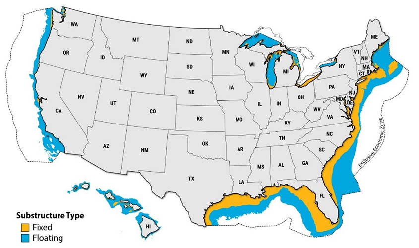
Overall, the project, funded by the U.S. Department of Energy's Wind Energy Technologies Office, focused on the evaluation of offshore wind energy technical potential in the contiguous United States and partitions results between fixed-bottom and floating offshore wind energy technologies across eight regions. Wind farm developers determine optimal substructure (either fixed to the seafloor or floating but anchored to the seafloor) by a variety of factors—such as component costs, installation and maintenance logistics, seafloor geologic (e.g., soil and seismic) conditions, and permitting—and may change over time as technology and conditions evolve. In this effort, a 60-m water depth considered a reasonable delineator between fixed-bottom and floating offshore wind turbine deployment (see map) for a high-level assessment from prior techno-economic modeling, but this water depth should not be considered a hard technical or economic limit.
Objectives
The objectives of this project were to:
- Update the assumptions used to characterize offshore wind energy technical potential, including turbine and plant spatial siting and density constraints, assumed seafloor depth constraints, and inclusion of the Great Lakes
- Quantifying the total technical potential for offshore wind energy in the contiguous United States as well as the relative share of that technical potential available to fixed-bottom and floating offshore wind turbine substructure technologies.
Publications
Offshore Wind Technical Potential, NLR Presentation (2022)
Contact
Share
Last Updated Dec. 6, 2025