
Tomorrow's Forecast: Sunny with a Strong Chance of Wind
NREL Resource Characterization Efforts Guide Offshore Wind System Decisions
How strong and steady will the wind blow? In what direction and at what time? The answers can have serious implications for wind energy systems.
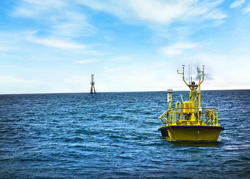
Buoys stationed off U.S. coasts, such as this one managed by Pacific Northwest National Laboratory, collect meteorological and oceanographic data that can help the wind industry make informed decisions for offshore wind power plants. Image courtesy of Ocean Tech Services LLC and Pacific Northwest National Laboratory
Accurate prediction and measurement of wind speed, direction, and frequency are vital to successfully harnessing energy from this renewable source. Assessments of offshore sites—which offer some of the greatest potential capacity for generating electricity from wind—include additional variables such as water currents, depths, and temperatures, along with volatile weather patterns.
Meteorologists, engineers, and geographic information system experts at the Department of Energy’s (DOE’s) National Renewable Energy Laboratory (NREL) are leading wind resource characterization efforts essential to the development of offshore wind. In collaboration with industry, academic, and government partners, the laboratory is providing measurements, data, and modeling needed for decisions by policymakers and commercial enterprises.
“Accurate wind modeling, forecasting, and validation with remote sensing measurements can improve offshore wind plant site selection, design, and operational decisions, while strengthening offshore systems’ abilities to withstand storms and other extreme ocean conditions,” said NREL Offshore Wind Platform Lead Walt Musial. “Precise resource characterization can be used to gauge the economic viability of an offshore system at a certain location and helps designers and developers maximize performance and profitability.”
NREL’s offshore resource characterization combines state-of-the-art numerical weather prediction modeling with validation against real-world observations, identification of meteorological phenomena, and estimation of wind speeds based on extrapolation of data from locations with comparable characteristics. Lab research evaluates offshore resources across the United States—including the North- and Mid-Atlantic and California coasts, Great Lakes locations, Alaska, and Hawaii—plus in other countries around the world. Government and industry partners provide opportunities to put NREL R&D into operation, while reducing investment risks associated with large, long-term offshore wind power projects.
Pinpointing Energy Potential: Measuring and Mapping
Robust, accurate data serves as the foundation for offshore wind characterization. Until recently, U.S. marine conditions such as wind shear, atmospheric stability, and turbulence had not been adequately recorded and tracked in relation to potential offshore installations.
“The sparseness of offshore hub-height wind measurements has been a major hurdle to accurate characterization of the U.S. offshore wind resource,” said NREL Senior Atmospheric Scientist Mike Optis. “Lacking those observation-based inputs, we have been forced to rely heavily on wind estimates from numerical weather prediction models, which often overpredict or underpredict the wind resource given the lack of validation data.”
Traditional buoy data only captures wind measurements close to the water level, rather than along the full expanse up to the top of the turbine, limiting the accuracy and application of these metrics. NREL and partners including the Bureau of Ocean Energy Management (BOEM) have developed new precise and reliable methods for documenting meteorological and oceanographic (metocean) conditions across the rotor span of turbines.
These new methods include using floating lidar units—remote sensing equipment that uses pulsed laser light to determine large-volume wind speeds—along with machine learning, novel machine-learning based methods of buoy data extrapolation, and integration of data sources for validation. The New York State Energy Research and Development Authority (NYSERDA), a partner with NREL in the National Offshore Wind R&D Consortium (NOWRDC), has helped validate these new technologies and techniques against established lidar systems and recently made wind data publicly available from two floating lidars off the New Jersey shore area.
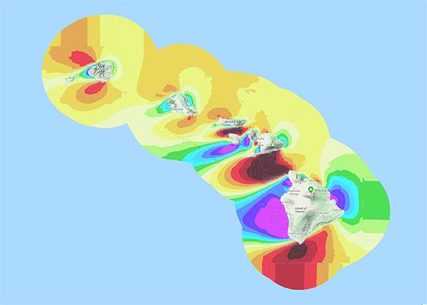
Offshore wind resource potential estimates and maps for states, such as this one for Hawaii, can be found on the WINDExchange website. Figure by NREL
NREL, along with partners from Pacific Northwest (PNNL), Argonne (ANL), and Los Alamos (LANL) National Laboratories, as well as from the NOWRDC and BOEM Pacific, is using data from those new sources and numerical modeling to update and enhance DOE’s Wind Integration National Dataset (WIND) Toolkit, the United States’ most extensive public data set of its kind. The original WIND Toolkit features data on meteorological conditions and turbine power for more than 126,000 offshore and land-based sites.
“The new data set will include meteorological data for 20 years made available at 5-minute intervals every 2 kilometers across the entire continental United States and its coasts, including the Great Lakes, Alaska, and Hawaii,” said NREL Senior Scientist Caroline Draxl. ”Uncertainty estimates of the portrayed wind speed values will be included and really help the wind energy community understand the benefit and limitations of the new data set.”
This improved data, paired with visualization tools such as static and dynamic maps available through NREL’s Wind Prospector, will greatly advance understanding of atmospheric and wind power plant flow physics as well as offshore wind and wave conditions. Ultimately, this effort will lead to more accurate estimates of offshore resources, power production, and design loads, improving the technical and economic viability of wind plants. NREL’s wind and water energy researchers are also collaborating to better characterize wave conditions that can affect offshore wind installations, while mapping U.S. marine energy potential.
Predicting Offshore Conditions and Performance: Modeling and Forecasting
Modeling is especially important in planning for offshore wind installations due to the scarcity of measurements that have been collected to date over the ocean. At the same time, offshore systems’ technologies and complex environments—including the interplay of air and ocean temperatures and currents, water salinity levels, interactions with coastal geography, prolonged high wind-shear events, and high wind speeds at altitudes where turbines operate—pose distinct challenges in matching measurements and operational wind plant performance with modeling.
Two collaborative modeling projects conducted by NREL and BOEM recently assessed the feasibility of renewable energy technologies in meeting the future needs of the Gulf of Mexico states of Texas, Louisiana, Mississippi, Alabama, and Florida.
“Gulf conditions pose challenges such as hurricane exposure, lower average winds, and softer soils that can impact technology choices and cost competitiveness in regional electric markets,” Musial said. “Offshore wind in the Gulf of Mexico has a resource potential of 508 gigawatts—twice the energy currently consumed in the Gulf states—as well as significant opportunities for growth in jobs and gross domestic product.”
NREL’s numerical weather prediction modeling capability combines global atmospheric models with observations, data assimilation, and simulations to help operators make informed market, operation, and unit-commitment decisions in planning and real-time scenarios. For example, the WIND Toolkit currently features atmospheric and techno-economic modeling capabilities for the continental United States, the Baja Peninsula, and parts of the Pacific and Atlantic Oceans, as well as for Canada, Mexico, and other countries.
Strengthening U.S. Energy Systems: Expanding Research and Industry Partnerships
A greater understanding of meteorological and oceanic conditions is still needed to optimize offshore wind designs, establish standards, reduce costs, and increase safety. Future offshore wind resource characterization efforts will focus on factors such as atmospheric stability, marine atmospheric boundary layer depth, surface layer depth and characteristics, and wind shear across the rotor layer, as well as fully combining wind-wave-wake models. To that end, NREL is collaborating with PNNL, Lawrence Livermore National Laboratory, ANL, the National Oceanic and Atmospheric Administration, and industry partners in a DOE-funded offshore atmospheric measurement campaign and on developing numerical model improvements for the marine environment.
NREL will continue to turn to its industry, academic, and government partners to identify offshore wind priorities, challenges, and real-world considerations that can benefit from future resource characterization efforts. For example, the laboratory is working with NOWRDC partners NYSERDA, Ørsted, Rutgers, Shell, Avangrid, and Equinor to establish a new validated national offshore wind resource database. Other NREL resource characterization projects involve ongoing collaboration with DOE, national laboratories, and BOEM, along with the Bureau of Safety and Environmental Enforcement, the National Center for Atmospheric Research, and the National Oceanic and Atmospheric Administration.
Partners rely on NREL for some of the world’s most comprehensive wind resource characterization capabilities, knowing that laboratory experts will factor in modeled and observed data, while focusing on atmospheric phenomena specific to offshore wind energy. NREL’s state-of-the-art uncertainty quantification and machine learning-based techniques for extrapolation of offshore wind speed measurements, along with regional wind farm wake loss analyses, provide the accurate scientific underpinnings industry leaders and policymakers need to make sound decisions and separate NREL’s approaches from those of more traditional site survey or resource characterization practices.
“These characterizations can be used for offshore wind forecasting, site prospecting, and energy, operations, and cost modeling,” Optis said. “They can also be used to formulate broader plans for grid integration and capacity expansion—and to strengthen the entire U.S. energy system.”
This is one in a series of articles on NREL’s offshore wind R&D. Learn more about the lab’s offshore, land-based, and distributed wind research, along with partnership opportunities.
NREL Offshore Wind Resource Characterization Data & Tools
Renewable Energy Atlas – Geospatial data and maps of U.S. offshore wind resources.
Renewable Energy Data Explorer – Data on land-based and offshore wind resource for more than 20 countries.
Wind Integration National Dataset (WIND) Toolkit – The most extensive public U.S. wind resource and grid integration data set, including data on offshore locations.
Wind Prospector – Visualizes wind speed data and analyzes the potential for wind energy off of Hawaii, the U.S. Gulf Coast, U.S. Virgin Islands, and in the Pacific and Atlantic Oceans.
Wind Resource Maps – Other maps of North American, Canadian, Mexican, Central American, Indian, and Bangladeshi offshore wind resources.
WINDExchange – This site, managed by NREL for DOE, provides state-specific data and information about wind energy, including maps of offshore wind resources for 27 states.
Last Updated Jan. 22, 2026