
Giving Vehicles a Safe Green Light
New Software Tool Helps Cars and Pedestrians Safely and Efficiently Share the Road
The light turns green. Then, suddenly, the sound of screeching brakes turns into the sickening crunch of metal on metal. A surprisingly high number of auto accidents—21% of all car crashes—occur at intersections with traffic lights. While these incidents are usually caused by driver error, new technology linked to roadway infrastructure can help prevent crashes resulting from human lapses of judgment.
The next generation of traffic signal control will not only need to prompt drivers with red, yellow, and green signals but also manage an environment that includes automated vehicles, pedestrians, and cyclists alongside conventional automobiles. An intelligent roadway infrastructure perception and control (IPC) approach can benefit everyone on the road, not just those who own cars with automated features.
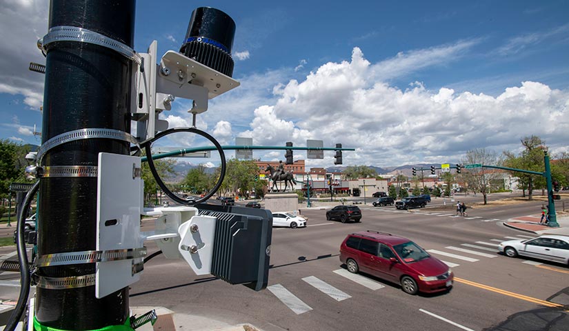
Researchers from the U.S. Department of Energy's National Renewable Energy Laboratory (NREL) are building an IPC computational engine to enhance the performance of connected and automated vehicles via infrastructure-to-vehicle communications and speed the rollout of next-generation traffic controls. This software tool collects and combines real-time data from infrastructure-based sensors such as radar and cameras to create accurate digital representations of intersection traffic.
Later this year, NREL will release the open-source tool online so that planners, researchers, and other users can merge sensor data from these multiple sources into a series of realistic, real-time simulations (or "digital twin") of traffic in a range of conditions and scenarios.
"We're optimizing the infrastructure and signal controls to work with cars' automated features, rather than focusing exclusively on vehicle technology and operation," said Project Lead and NREL Postdoctoral Researcher Rimple Sandhu. "Doing that, we'll be able to put a safer overall transportation system in place sooner, to create a world where self-driving cars can safely coexist with older model vehicles, as well as with people on foot and on bikes."
Many cars on today's roads already have automated features such as self-parking, adaptive cruise control, and blind-spot detection. Unfortunately, the pace of fully automated (or self-driving) vehicle deployment has been hindered by safety issues and a lack of vehicle-to-infrastructure connectivity. One challenge is that a single vehicle cannot fully sense its surroundings in roadway environments with complex mixes of vehicles and other users.
Cooperative driving automation (CDA) embedded into the infrastructure, rather than individual cars or trucks, can increase the safety, efficiency, and reliability of the entire transportation system—especially as vehicle automation increases. This approach will make it possible to improve safety more quickly and economically by making improvements to the approximately 300,000 signal-equipped road intersections, rather than changing the nearly 300 million vehicles that travel those roads.
The NREL-developed IPC engine will use advanced infrastructure-based sensing communicated to manufacturer-installed vehicle automation features to improve safety and fuel efficiency, while reducing greenhouse gas emissions. A combination of infrastructure and vehicle sensor readings from multiple vantage points not only makes the resulting digital model more accurate but also enables it to detect and measure potential weak spots in safety and cybersecurity. Additionally, the "digital twin" IPC framework allows multiple application developers to share validated models of intersections and collaborate on innovations. Furthermore, NREL researchers are leveraging the information from IPC for energy-specific applications that can benefit buildings and the grid.
Data-Informed Tool Validation
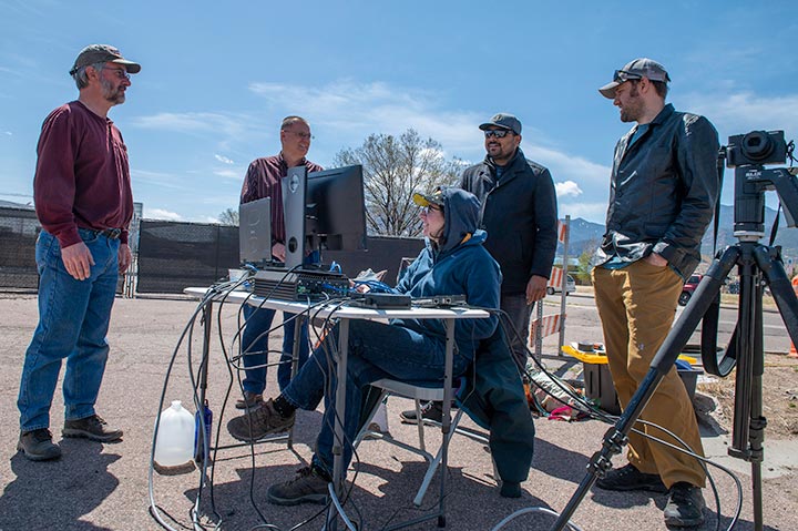
The laboratory recently partnered with the city of Colorado Springs to collect vehicle and pedestrian data that will be used to assess, tune, and validate the IPC tool. Data were collected using radar and light detection and ranging (LiDAR) sensors installed on poles atop lift trucks. The LiDAR and radar equipment were mounted identically on two masts, or poles, and the poles were oriented in different directions to enhance the sensor coverage area. Two human-driven test vehicles—each equipped with high-accuracy GPS units that captured the "ground truth" of the vehicles' motion—performed various maneuvers in relation to the placement and orientation of the sensors.
The radar, LiDAR, and GPS data serve as a validation data set for the IPC tool, which merges vehicle and pedestrian tracks detected by the sensors while advanced Bayesian filtering algorithms fuse the various tracks and compute a unified traffic picture.
The collected data highlighted the strengths and shortcomings of each sensor type. For instance, LiDAR detected vehicle shapes more accurately than radar, but it also had more false detections.
Applications and Benefits
IPC-enabled applications include connected eco-driving and traffic signal optimization to maximize fuel economy and efficiency and pedestrian-activated alerts for improved safety. Highly competitive commercial automakers closely guard their intellectual property, limiting the amount of publicly available information on automated vehicle technologies. NREL's open-source IPC tool will support and inform the development of a multitude of applications connecting vehicles to each other and transportation infrastructure.
Recognizing the need for infrastructure designed to communicate with automated vehicles, the U.S. Department of Transportation launched the Cooperative Automation Research Mobility Applications (CARMA) Streets initiative. NREL's project provides high-fidelity readings, rapid and accurate computations, and communications from the infrastructure-based IPC engine, which can be used with the CARMA Streets framework.
"Automated vehicles are critical elements in our transition to a zero-emission transportation future," NREL Mobility Innovations Team Lead Stan Young said. "These IPC breakthroughs will play a vital role in making that happen."
Learn more about NREL's efforts to integrate automated vehicles with transportation infrastructure, as well as the laboratory's broader body of transportation and mobility research. To explore IPC partnership opportunities, contact Young.
This article has been updated to reflect an editorial change made after its original publication.
Last Updated May 28, 2025