
Assessing the Wind Power Potential in Bangladesh
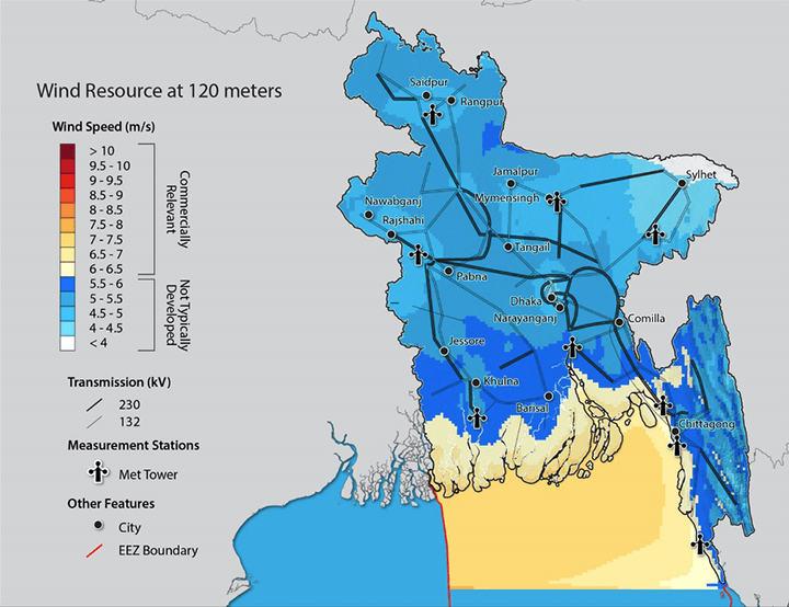
A detailed wind resource map for Bangladesh. Researchers from a USAID-NREL partnership collaborated with the Government of Bangladesh to assess the country's potential and risks for using wind power as part of its renewable energy mix. This map, and other data from the assessment, are available to the public on the RE Explorer geospatial tool.
A collaboration between the United States Agency for International Development (USAID) and the U.S. Department of Energy's National Renewable Energy Laboratory (NREL) used a unique combination of tools to determine the viability and risks involved in using wind power as a renewable energy resource in Bangladesh. Those tools included the following:
- Long-term, correlated, global wind data sets
- Validated high-resolution wind resource maps
- Publicly available data accessible through the RE Explorer geospatial tool.
The recently published analysis, Assessing the Wind Energy Potential in Bangladesh, explores a collaboration with the Government of Bangladesh to help address significant challenges that include power shortages, increasing demand, decreasing domestic natural gas reserves, and an inadequate transmission infrastructure.
The assessment improved upon existing global data sets by using best-in-class modeling techniques and analyses. While global models are good first steps in predicting wind resources in various parts of the world, they are not accurate enough to predict project risk and stimulate investment in renewable energy. The Bangladesh assessment improved the quality of modeled wind resource data for the country. The data is available to investors and the public through the RE Data Explorer tool, which allows users to perform customized technical potential analyses.
In addition to the modeling effort, the project team used a multi-year, local data-collection campaign to validate the model and further improve the accuracy of the data sets. The campaign consisted of nine meteorological sites representing all geographic regions of Bangladesh.
The data gathered and analyzed in the assessment supports the need for informed decisions by the Government of Bangladesh ranging from policy and investment to reliable power sector planning. Research results will help reduce technical risk and encourage private-sector investment in the emerging wind power industry in Bangladesh. The Government of Bangladesh may also use the assessment to develop policies to encourage domestic and foreign investment in renewable energy. The Government of Bangladesh has committed to using renewable energy for 10% of its total generating capacity by 2021.
Last Updated May 28, 2025